
|
It was midnight on July 13th/14th and Roisin and I were not long home from what turned out to be our best chase day of the season and the most significant thunderstorm outbreak in Ireland so far. We had been at Rosse's Point in Co. Sligo watching a huge 80km long multicell thunderstorm slowly creep from the west coast out over the Atlantic during the late evening hours, the chase was a total success and turned the entire season around for me.
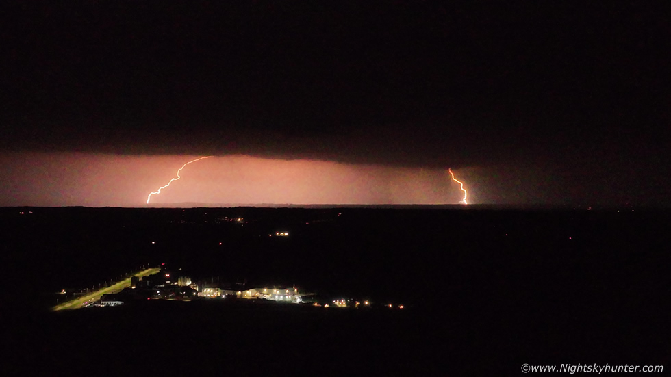 |
We where back in Cookstown when the radar suddenly revealed elevated storms over Belfast migrating N across Co. Antrim. I stepped outside into the warm night air at 02.00 and watched big flashes of lightning from those storms far away to my E/NE, what a fantastic treat to witness after such a positive day out. I sent the drone in the air to record video not expecting much but was surprised to capture several c-g strikes including this double whammy, needless to say I was buzzing and by 03.00 I called it a night.
Sleep was fleeting due to the warm still night, the excitement from the day, and the anticipation of what might happen the follow day. July 14th was showing widespread CAPE across N. Ireland into the evening hours with cold tops and strong enough shear during the first half of the day for multicells on a light Sly flow. I was anticipating a classic Summer chase, it always was a good sign when instability was in play well into the evening hours and I was looking forward to a long chase day. I woke up at 05.00 on the 14th and did a sneaky check of the models, even at this hour my mind was trying to work out where was the best place to go. The trusty AROME was showing random cells everywhere, it was difficult to know to head N, W, S or E, I wasn't quite sure what to do.
By late morning I was sipping a brew doing another check through the models when the atmosphere rumbled with thunder, a storm already! and at home, what a rare treat. It rumbled again, it had snuck up on me like a ninja so I never seen it coming and radar showed it had developed rapidly from nothing. Above the house the cell had a high based look and a weak arched gust front passing over with very subtle whale's mouth, nothing photogenic but I don't know anyone who would complain about getting thunder from home, I just watched the cell from the yard and enjoyed not having to rush for the drone or camera, sometimes it's important to know what's worth shooting and what isn't, this was a great way to start the day from nature. I felt encouraged, activity this earlier surely must indicate a very active day ahead.
I was chatting with John Fagan online about the set-up as he was planning on chasing too, we were still finding it difficult to know where to go, the models just weren't clear cut. Based on several models it looked like the W would be more cluttered with showers which could mean more cloud and a mess, where as the midlands and E had more isolated showers/cells which meant better solar heating and better for photography so for the time being I decided to stick with the zone between Co. Tyrone and Co. Antrim, perhaps even hitting the lough later. I had all my gear packed into the van and did one final check of the sky, there was a developing fairly robust cell in the distance to my S and since the flow came from that direction I decided to wait and see what happened as it would be heading straight for Cookstown. The leading edge was a long base with precip breaking out, on it's left (E) side was a strong updraught bulging upward and forming into a fuzzy anvil, I knew by looking at it that it was trying to be a storm. No sooner had I thought this when I heard a loud rumble of thunder, a storm was born, the second of the day. I sent John a text saying 'storm!', as it turned out it was rite over Dungannon where John lived, he had the drone up getting images and captured a very nice c-g bolt on video.
 |
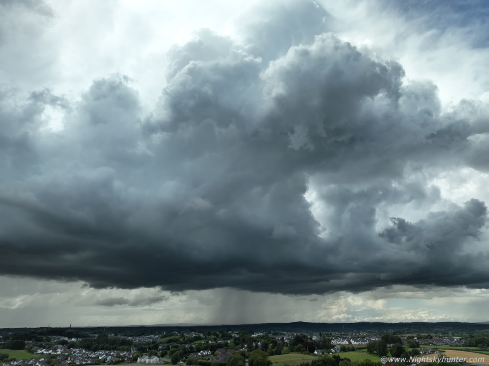
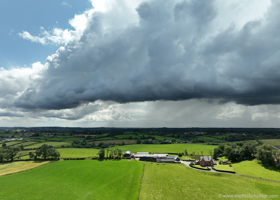
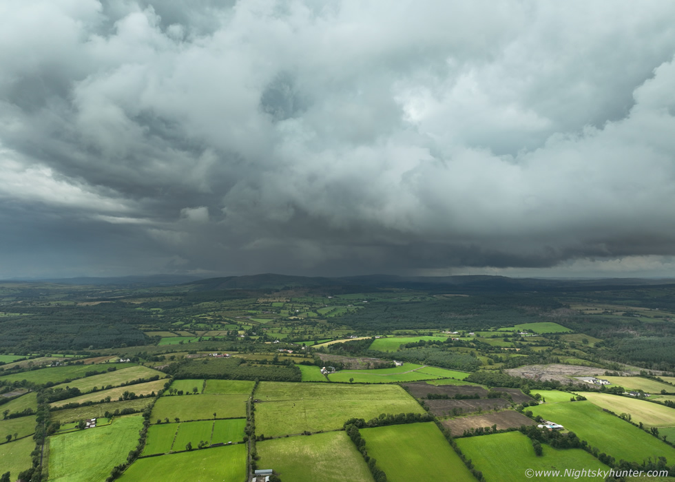
It was getting closer to Cookstown, another rumble, I jumped in the van and drove out the road not exactly sure where to go. Should I drive towards it which meant getting stuck in slow Cookstown traffic to the S before I got into the countryside or head N and get ahead of it? what if it died out if I went too far N. I decided I would stay where I was. I drove onto the main carriageway and pulled into a layby adjacent to the fields which flanked the road and got the drone up for a look. The storm extended across a large section of the S skyline, the light was brilliant but very high contrast and harsh. At this time of day strong sunshine was shinning down from high in the sky causing short dark shadows and lush colours in the fields. The vibrant countryside contrasted nicely with the storm, it was a good day for photography.
A curved line of updraught towers made up the storm however it was a very strange sight. First of all the towers were slightly high based but didn't seem remarkably tall, if I hadn't of heard the earlier thunder and looked to the sky for the first time I would have said they seemed a little low topped to be capable of thunder, yet this was a thunderstorm. The anvil aloft was fuzzy and weak, I'd seen better examples than this in Winter time and look at the precip falling, incredibly weak visually yet this had red and white cores on radar, perhaps it's high based nature had thrown me off. In any event it was still an interesting sight over the fields and I wasn't complaining believe you me. Some of you might recognize the house in the foreground, that's the striking red brick farm house among the fields on the left hand side just before you arrive in Cookstown.
 |
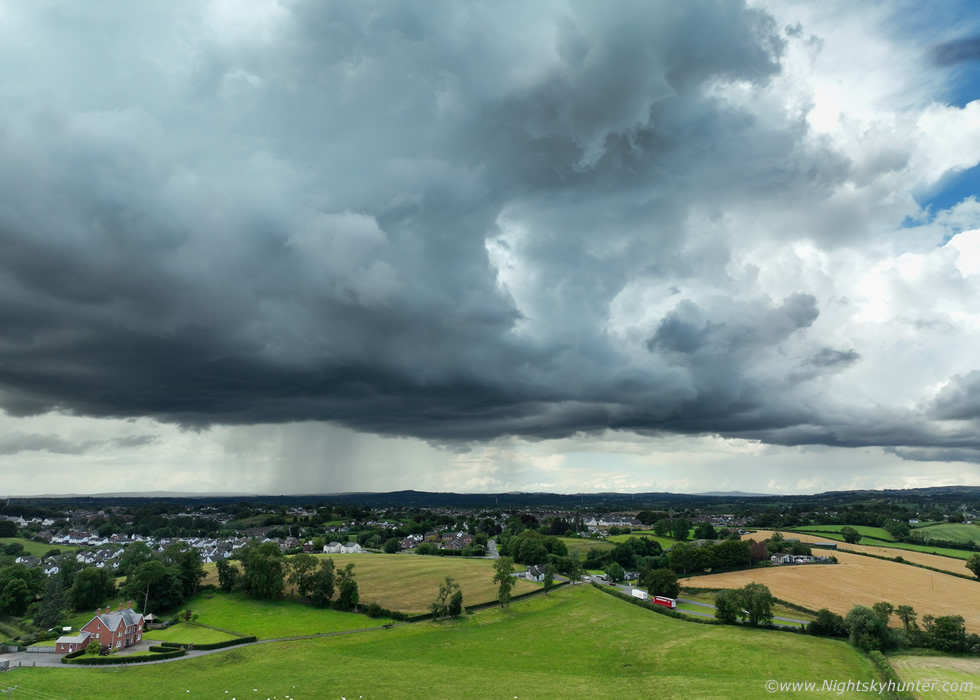
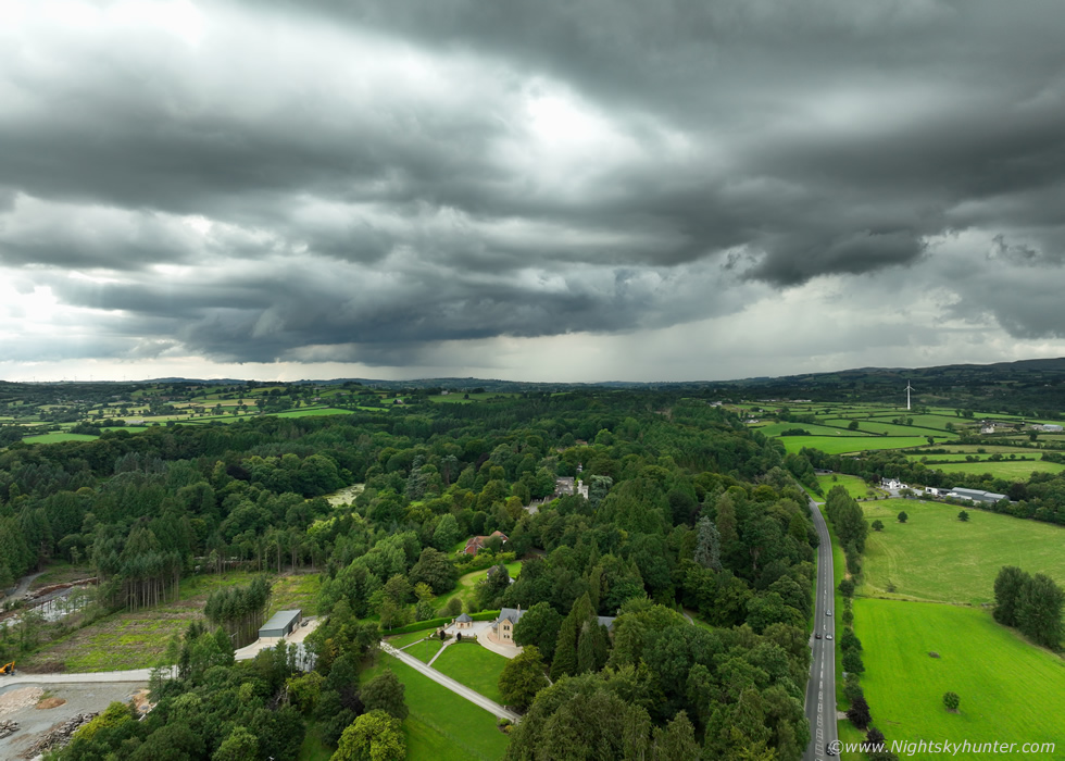
Mid section of the storm with Cookstown way in the background, you can see the chapel spire sticking up on the left. Drone camera panned upward to show the top of the towers which were now getting very dark and the light in that direction was harsh looking towards the sun through a cirrus anvil.
 |
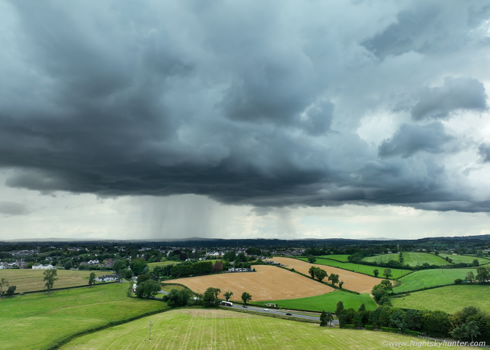
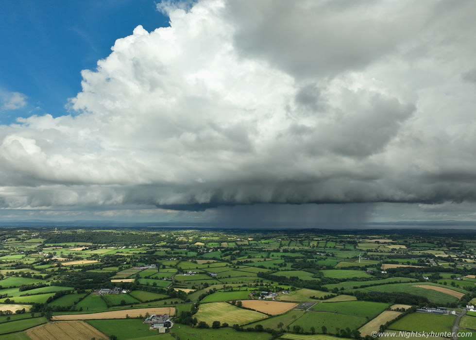
Panning to the right along the leading edge, half the storm was dark while the far end (W) was in bright sunshine making for quite a high dynamic range scene even for the excellent four thirds sensor on the Mavic 3. I'm a structure guy, I wouldn't say this was impressive or mean or overly photogenic, but I did place it within the category of 'interesting'.
 |
I thought it was spent then another rumble of thunder boomed from high up inside the towers, I saw no lightning at all, but that didn't mean I was safe, a rogue c-g was possible anytime with any storm, weak or strong it didn't matter, it's always important to keep situational awareness.
 |
Back to the W side which in my opinion was much more photogenic, the storm was a lot closer to me and the drone then it seems in this wide angle image, I began to feel the first light drops of rain on my head so I raced the drone back in sport's mode. Just as I landed the heavens opened up, by the short time it took me to pack the drone into its bag standing at the rear of the van I was soaked rite through, I ran inside, the windows were down and the seats were soaked and my dog Rhua was getting rained on. I got the van on and windows up then a monsoon rainfall hit which was shocking as it didn't look like such a big deal when I last saw the core, no wonder the radar was showing white echoes. More thunder began to rumble, this time a cluster of perhaps half a dozen.
John rang to tell me about his storm encounter while occasional rumbles stirred among the heavy rain drumming off the roof. John said radar showed the lightning was over the N section of the storm now near Slieve Gallion and Draperstown area, it was moving N so I decided to let it go and concentrate on any future storms to come. John and I brain-stormed (no pun intended) over the phone, where to chase?, so far no sparks in the W, it looked way too cloudy and the E had nothing at all, even convection was scare there, it seemed the best place was the Mid-Ulster area. We speculated that since it was so warm and sunny here and hence great solar heating then this looked to be the best area for storms. After all we had two storms already over our home areas of Co. Tyrone and based on radar the trend was showing the border to Co. Armagh to Co. Tyrone as the places to be. How lucky were we this day to have a target area in our home county without having to drive too far. John said he could see convection approaching his area so it looked like Dungannon was a good location so I said I would meet John there.
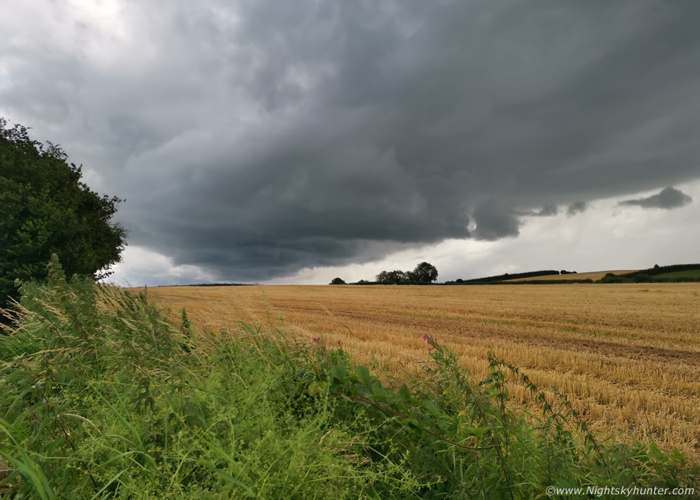 |
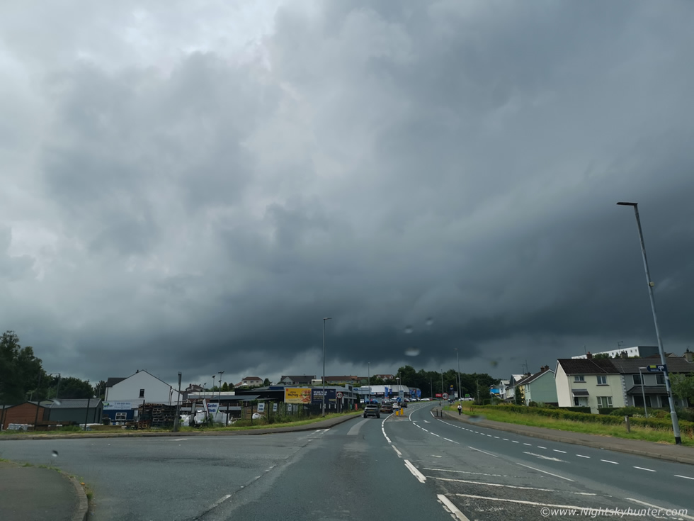
As I was driving through Cookstown John rang again, he was getting another storm, that's how quick things were happening, that storm was heading my way and once I got through the town I could see a very dark dark base approaching from the S, that was John's storm and it was edging close to Cookstown already. I took the turn off for Cabin Wood and got out for a look, this was the storm passing over the fields, it gave me one rumble of thunder, my third storm of the day. It was too close to put the drone up and my view wasn't good with trees around so I took this one snap using the phone. The storm weakened and died, so I got back in the van and drove S.
I met John in Dungannon then we re-located to Castlehill in the town, a place I had never been before. We had a great view all around for anything more coming this way. It was very warm and the sun was shinning, solar heating was great, it seemed all the boxes were being ticked and it was just a waiting game. Suddenly a fantastic line of convection formed to our W moving N, several potent cells were soon in view and one particularly huge cell with bubbling towers and growing anvil really got our attention. Where did all that come from? and out W too, we stood our ground assuming the same parameters would be moving near here later but we confessed we were not liking the sky, too clear, no real convection, it didn't look promising, it was obvious the W was now the place to be. Radar showed the big growing storm was heading over the Sperrins and would actually pass near An Creggan, we where well out of position but decided to go for it.
We drove back out of Dungannon onto the main road, John rang saying about taking the road to sandholes area then make another decision from there, the cell looked to be a lot closer than expected. I ended up stuck behind a slow moving camper van and couldn't pass for a long time and I lost sight of John. Eventually I did get pass and took a random road on the left with Sandholes wrote on it, turned out it was the wrong road, then I was trapped on narrow twisting country roads with trees and hills and with little in the way of signage, I was committed now and just kept going knowing I would end up on the Omagh Road at some stage. I got glimpses of the cell between trees, nice white convection, a solid high base, dark core, all over sunlit fields, I wanted to stop to get the drone up but I never could find a decent place to pull over and eventually the cell passed to the N and weakened and I had to let it go. It was the fourth storm of the day but I never got peace to stop and hear the thunder. I ended up in Omagh and the atmosphere had changed, the convection was smaller and mushy looking, even capped, it looked like the day was over, there would be no evening storms. At least it was a nice sunny afternoon, I headed back home content enough, at least the driving was a bit of an adventure.
Things became somewhat of a blur after this with multiple convective outlooks issued, I chased on six days out of seven, however there were some terrible busts. The following day, July 15th, surprised me, the Met Office had a yellow warning out for thunderstorms and for the life of me I just couldn't understand why. I saw no potential, the cloud tops on the models were barely cold enough for thunder despite instability present. This was all associated with a wrap around low bringing in bands of showers from the N/NW, a set-up which I never have liked in the past, it meant lots of cloud and grey skies and that's exactly what happened. Solar heating was shut off yet again and the atmosphere looked and felt saturated. Cells/showers did develop in the form of red and white cores, I went chasing anyway in case of funnels, I targeted Tobermore/Moyola River and didn't like what I was saw, as soon as a tower formed its base immediately filled in with precip, there was no time for a base to remain visible to do anything, I had seen this before, it meant a wet day with no structure. I followed the activity S to Ballyronan Marina and got under some of the big downpours, no thunder as expected, I still never understood why a thunderstorm warning had been issued. There was rapid rotation witnessed near Toome which was interesting thanks to the low level shear and convergence but other than this the day was a bust, I cancelled the chase by 14.00.
One such day looked to have great potential with thunderstorm warnings for W. N. Ireland from the Met Office. Models showed what looked like a big squall line crossing the country head of a cold front with high confidence on a shelf cloud on the leading edge so this became the goal. Omagh and Sperrins kept getting flagged so this was the target area. I went to Beaghmore where I met Colleen Webb but we didn't like the look of the atmosphere at all. It was grey and cloudy with no heating, I've seldom had a good chase day that began like this. Big showers broke out with red cores, the bases were low and dark, there was swirling scud and even some rotation but it seemed disorganized despite the good shear, the cells were fast moving, and the atmosphere felt saturated, I wasn't liking it at all, I knew the moment I left the house this was going to be a bust, yet I always get lured out anyway.
We got so fed up sitting under rain not doing anything we moved away from the showers further W into dry air and met Paul Martin where we spent the evening not far from Omagh. A line did appear on radar but it looked rubbish, there where some strikes over Galway which died out and later over Donegal and out to sea however the sky was awful. We waited and waited for the cold front to approach us hoping for structure or a rumble of thunder, but it was dead, the front took longer to come in than expected and the CAPE was weakening and tops got warmer, so much for the warnings, there wasn't a single rumble in N. Ireland at all. We waited until 20.30 then gave up and went home, it turned into a rain event and not even heavy at that. On to the next chase.
 |
July 18th was one of those days which would only interest us convective maniacs. It would be a good sunny day with only 100j/kg of CAPE and the television forecast was going for a few rumbles of thunder from heavy showers. I checked the charts, the cloud tops were borderline, just below -20c, it would be a close call but I reckoned the chances of thunder were low to none. However with convection about and good heating I always keep an eye out for surprise scenes, sometimes these kind of days can catch you off guard and be photogenic, like this day turned out to be. I hadn't planned on chasing however I knew the models were showing random cells during the afternoon and evening, especially in the Tyrone and Antrim areas. It was a Sunday and we had visitors over for dinner.
I had just finished eating when I got a call from John Fagan asking me if I had been watching the sky for convection, at first I thought he was having a laugh but realized he was serious. He was seeing good big towers in my direction so I stepped out the back for a look. I had to admit the sky was very interesting, far more impressive than the bigger set-ups had produced over the last couple of days. Close by to my E near Cookstown was a lovely cell with at least four tall white updraughts shinning brightly in the afternoon sunshine. Those updraughts were quite solid and taller than I had expected, in fact, they almost looked like they were trying to become a storm. We chatted over the phone and commented on this cell and another big one to the N near Maghera. The cell near me already had a red core, the cell went down fairly low with a good textured base, it was a nice surface based cell, the kind I really like.
I kept watch on it as it slowly moved NE. I couldn't get away chasing yet so I got the drone in the air for a look and ended up having to fly out across the countryside in pursuit. It really was a lovely sight, the precip core was now white on radar which also indicated it was over the W flank of the Lough Neagh basin and further away than I thought, which meant it had grown even bigger. It didn't rumble however it was a looker, the base was really cool with a compact shelf structure, I shot video clips and took stills and eventually flew back before my battery got too low. Before I landed I showed our visitors the view on the RC's screen and they were all fascinated. Half an hour later another cell formed, red on radar again, it was over Coalisland and began moving N along the side of the lough once again, this one had a long low dark blue thundery looking base, our visitors were leaving so we decided to give chase while keeping expectations low.
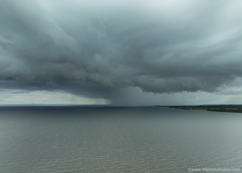 |
Roisin, Rhua and I took the back roads along the old Coagh road and in little time we had made it to the shore of Lough Neagh at Ballyronan where there was hardly anyone about, which was nice. The evening was warm and calm and quiet. The cell came into view, crossed from land to water, the base all dark and mean and that core was still white on radar. There was a small shelf feature marking the edge of the outflow's influence and the sky began to cloud over, not cold, just a nice pleasant cooling on a Summer's evening. Moving R to L and slightly towards us.
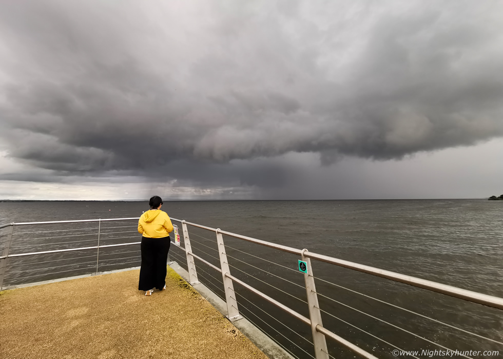 |
The cell really did try, the sky turned dark and moody, there was a sensation in the air of thunder, it felt like a charge was trying to build, we could sense this cell tried its best to break through the atmospheric hand cuffs and free itself into the storm it wanted to be, but it couldn't quite get there. It remained in captivity to the borderline cloud tops inside it's invisible prison over the lough. I got my phone out and asked Roisin to step into the frame, her yellow jacket contrasted nicely with the moody sky, full wide angle, final image of the day. Despite no thunder we enjoyed the fun local chase and the cell was cool enough to experience anyway.
July 19th was another chase day, this day it was just Rhua and I, we had hit the road at 11am to make good time. CAPE was modest, shear was good enough for multicells but yet again the cloud tops were too warm for thunder, I knew this, however the Met Office had yet another yellow thunderstorm warning over the W side of N. Ireland, I was shocked yet again why this was the case. I was going for structure and funnels not expecting any thunder, where was all this coming from?, I paid it little heed but in a way it felt good that there was a warning in the first place. The target areas looked to be Co. Fermanagh into Co. Donegal, my plan was to try the Kesh area which was as far W as I intended to go this day. When I left home it was grey and cloudy once again with no heating and the sky had that saturated look once again, I knew it wasn't going to go well but I wanted a day out anyway and an adventure for Rhua so I stayed relaxed with low expectations.
 |
Passing through Omagh a nice cell crossed the skyline directly in front of me, the base was almost a a ground hugger and a chunky lowering had formed with interesting scud motion, not striking enough to decide if it was a shallow wall cloud or just outflow scud, likely the latter, but I wanted to keep an eye on it incase of a funnel. The towers above were actually quite beefy and moderate in height, you can just glimpse some of them above near the edge of the phone shot.
 |
I got out of the town onto a more open road, that lowering was still visible. Then I lost sight of everything as a heavy shower went over me, next thing I knew the cell was over the other side of the road and moving out of view over the countryside and it was back to dry roads and grey skies. I wasn't feeling it at all today so I was in no rush, I had mentally turned this into a 'day out' and if anything convective happened it would be the icing on the cake. I was feeling nostalgic so I stopped off in a small village outside Edenery where a church was visible in the countryside, at its rear was a famine pit, a spooky and historically interesting and sad part of Irish history. I recall stumbling on this place many years ago when I started my first chases to Fermanagh and beyond, it was actually nice to see it again, little had changed, it was almost like it was frozen in time while I had become older between visits. I enjoyed the explore then drove on to Kesh.
 |
Outside Kesh I spotted a new cell, the best of the day, it was a fair bit away and looked to be back near the Omagh direction or N of there. I got the drone up for a look while Cows bayed behind the hedge beside me wondering what the funny noise was. This was about as 'photogenic' as it got this day, dark base on right, precip on left, on radar this was a sheared line of red reflectivity. The tops were hidden behind mid level cloud, and of course they were too warm and it never produced. There was no thunder in the entire country today or any flooding rainfall to justify warnings, in fact, only a few well isolated heavy showers formed which most people paid no attention too, it was pretty much as the models made out, no drama. I didn't get any funnels and visibility wasn't clean enough for structures so after having a nice walk around the lake at Kesh I made my way home for 16.00, an early enough return for a chase day. I still enjoyed the day out and filmed a vlog of the bust chase.
 |
July 20th, last but not least, I felt like I was living in Ground Hog Day, it was deja vu all over again, another Met Office yellow warning for thunderstorms, a wrap around low feeding in a belt of convection from NE to SW with borderline tops but good CAPE and enough shear for multicells. There were periods of warm sunshine with towers all over the sky, the bases looked somewhere between high and elevated in places. I didn't chase as I knew there would be no structure today. There were reports of thunder W of Omagh and Carntogher and near the border, I let everything pass my area as it had little photogenic value but by early evening I got tempted out for a local case, a cell with red and white cores came into view N of Cookstown making its away over the Sperrins near the Omagh Rd so I shot out for a look, I pulled into a lay bay and could see it crossing a fair bit of sky.
Drone up looking E along that road, the leading edge had a weak shelf and it was more surface based, but the precip core looked so weak despite what the radar showed, unfortunately no thunder and it wasn't interesting enough to keep chasing so I let it go. Enniskillen ended up getting hit bad with a multicell which dumped alot of rainfall causing major flooding with dramatic footage of a rescue from the Marble Arch Caves where water was flowing in at high speed, this appeared on the evening news. The culprit was a back-building training thunderstorm which alone validated the yellow weather warning on this occasion.
This brought to an end a busy week of almost back to back chasing. Normally I would consider many of these images unworthy for inclusion on the website as they didn't tick my personal box of standards and were not dramatic enough so to speak. However each one of these days cost an effort, time, energy, strong emotions and money so I felt it was worthwhile documenting the weak pulse of this season, after all, it's what nature has presented me with so I will have to make do in the meantime.
In summary the Mayo/Sligo storms are currently the convective event of the Summer and year, that day was exceptional and really produced. The rest of the season to date has been awful and N. Ireland has been dreadful for proper convective skies, currently I rank 2025 as the worst convective season on my personal records since first chasing in 2007 and I see little hope in the future. As I write this there are hints of warm HP returning but it doesn't appear thundery, there's also a lot of cloud cover and horrible influences from the NW which at times reminds me of Autumn. As of rite now I see no hope of this season turning the tables, it just has been an awful with little sky action to show for it. Thank God I chased to Sligo that day!
Despite my complaining we still have August and September to produce the goods and I will be watching the models carefully, after all, it only takes one good day to make an entire season. The nights are getting a little darker so I will soon be looking forward to getting out under the stars with the telescope and shooting the Milky Way and hunting for the aurora.
Vlog covering several days of chasing from the Cookstown thundery showers to the busts and even the visit to the famine pit. Thanks very much as always for taking time out to read these reports. I hope that the next time you come on here I will have images of something more interesting to write about. In the meantime why not check out my chase report from Sligo as it has much more detail and is full of energy and a great buzz from chasing great storms.
Martin McKenna
